Ground control points (or GCPs) are known-coordinated places on the ground. GCPs are points that a surveyor can precisely pinpoint in an aerial mapping survey, allowing enormous areas to be accurately mapped with just a few known coordinates.
Anything that may be easily recognized in the photos can be used as a ground control point. They resemble a small section of a checkerboard in appearance. The form eliminates any doubt about where a ground control point’s ‘point’ is. Because high contrast patterns are easy to notice, they’re virtually always black and white.
The points might have been measured using classic surveying methods, LiDAR, or an existing map, including Google Earth.
Here are the reasons why DT Research GNSS rugged tablets are the best tool for the most accurate ground control points:
Survey grade GNSS
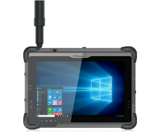
GNSS Rugged tablets from DT Research include high-accuracy GPS and can integrate mapping software that can reference photogrammetry to collect images from drones, resulting in a complete 3D view of a site. This GNSS rugged tablet working as a receiver boosts productivity by continuously delivering RTK positions, even in the most challenging conditions. The receiver works in low-satellite-visibility locations, such as near high structures or beneath the foliage, thanks to multi-frequency multi-constellation GNSS technology.
Data Controller
Surveyors want a system that is constructed for rigorous use but also has a high-visibility screen, an easy-to-use interface, and a long battery life in order to gather data effectively and confidently. Many data collectors claim to have these features, but when tested in the rigorous conditions of surveying and building sites, many of them fail. Depending on your application, the DT Research GNSS rugged tablets can be loaded with a variety of data-collection software packages. Several data-gathering programs are also compatible, depending on the level of precision requested by the user.
Connectivity
Connectivity is available through built-in dual-band Wi-Fi and/or 4G LTE communications as well as long-range Bluetooth connections where needed. Rugged tablets can access other equipment and manage them from the rugged tablet itself.
Site image creation made faster
DT Research’s GNSS rugged tablets are more than just a fancy traditional surveying data collector; the Intel RealSense Depth camera and integrated software from partners are comprehensive additions to the rugged tablet that make it shine. Intel’s latest technology allows users to picture and video locations that are inaccessible to even the most advanced laser and Lidar scanning equipment.
The ground control point (GCP) network must be established before raw image data can be georeferenced. DT Research has provided a window into what the future of data collecting looks like, no matter what profession one is in, by incorporating all of this technology into a rugged computing solution that can run on industry-standard software platforms.