Flooding doesn’t just happen during hurricanes on the coast. In recent years, we’ve had floods in areas seen as “normally dry,” inland areas, and places where people rarely worry about heavy rain, transformed into disaster zones in a matter of hours. The speed and sheer volume of water are staggering, leaving behind billions of dollars of damage to properties and people’s lives at risk.
It is often hard to see how much damage a flood does while on the ground. Debris blocks roads, power lines go down, and landmarks vanish. In these high-stakes moments, the combination of Unmanned Aerial Systems (drones) and rugged tablets has become the “eyes and ears” for first responders and city planners.
Seeing the Unseen: The Role of Drones
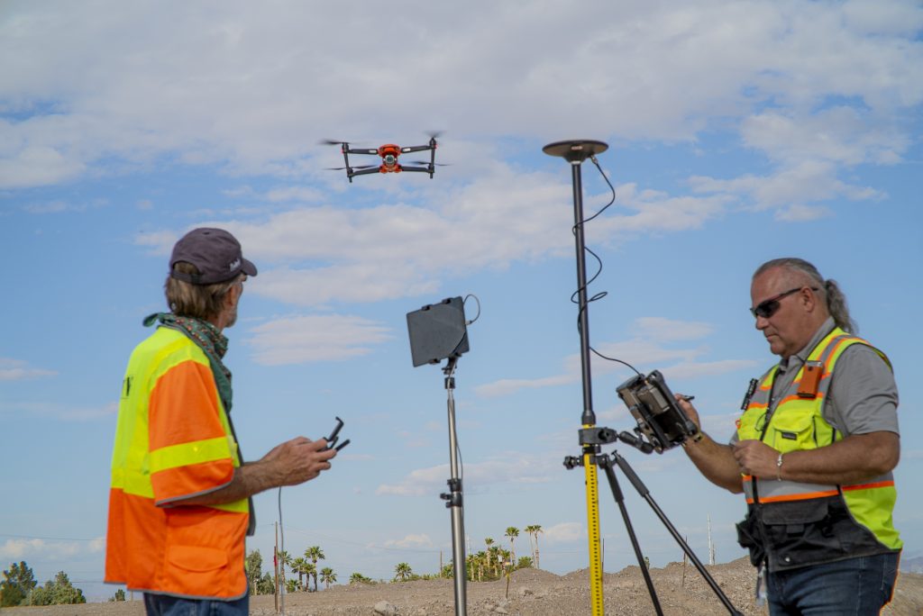
Traditional flood assessment used to rely on helicopters or people on the ground, both of which are expensive, slow, and often dangerous. Today, drones can be deployed in minutes. They provide a bird’s-eye view of where the water is flowing, identifying which levees are failing and where residents might be stranded.
But a drone is only as good as the interface the pilot is holding. In a flood zone, you aren’t sitting in a climate-controlled office; you’re standing in the rain, surrounded by humidity, mud, and chaos. This is where the consumer-grade tablet fails, and the rugged tablet becomes a lifeline.
More Than a Controller: The Mobile Command Center
While drone flight is a primary use case, rugged tablets serve as the “brain” of the operation well beyond the cockpit. In flood management, these rugged computing systems are utilized for:
- Real-Time Infrastructure Inspection: Using integrated cameras, engineers can scan bridges and levees to evaluate structural shifts or debris accumulation that the naked eye cannot see.
- Dynamic Rerouting and Logistics: When roads are submerged, rugged tablets enable incident commanders to update digital maps in real-time, rerouting rescue vehicles and supply trucks away from areas that have suddenly become impassable.
- Multi-Agency Coordination: During a flood, information can get messy. Thus, communication between police, rescue, and utility crews is vital. Using rugged tablets as unified communication hubs allows different teams to share high-resolution damage photos and GPS-tagged evidence instantly, ensuring everyone is working from the same “source of truth” and that information is updated for everyone in real-time. This ensures that every person in the field and at headquarters is making decisions based on the same, most accurate information.
Why Rugged Tablets Are Non-Negotiable in Flood Zones
Managing a drone fleet during a disaster requires more than just a touchscreen. It requires a built for the mission. Rugged tablets are designed specifically for these environments, offering features that standard devices simply can’t match:
- Sunlight-Readable Displays: Flood assessment often happens under the glare of a post-storm sun or through heavy rain. High-brightness screens ensure the pilot can see every detail of the drone’s high-definition feed.
- IP65 and MIL-STD-810H Ratings: Water and electronics usually don’t mix. However, rugged tablets are built to be water and dust-resistant. They are built to withstand shocks and drops. The mission doesn’t stop if you drop them in a puddle or get caught in a downpour.
- Hot-Swappable Batteries: Disasters don’t follow a schedule. You can’t afford to wait four hours for a device to charge. With hot-swappable batteries, you can swap out a low battery for a fully charged one without ever powering down the tablet, ensuring 24/7 operational readiness.
- Gloves-On Operation: When you’re in the field, you’re likely wearing protective gear. Rugged tablets feature touchscreens that respond to gloved hands, so you don’t have to compromise safety for connectivity.
- Integrated High-Precision GPS: In a flood, the landscape changes. Integrated GNSS allows responders to map damage with accuracy, helping utility crews find submerged infrastructure or providing precise coordinates for search and rescue.
From Coastlines to Canyons
In coastal areas, the threat is often predictable: storm surges and rising tides. But in dry, arid regions, flash floods can be even more lethal since the ground can’t absorb the water fast enough.
By using rugged tablets to control drones, emergency managers can create real-time 3D maps of the terrain. This “digital twin” of the flood zone allows them to predict where the water will head next, giving them a head start on evacuations and resource deployment.
Flooding is one of the most destructive natural forces on Earth. While we can’t always stop the water from rising, we can certainly get better at managing the response. By putting the power of aerial intelligence into the hands of responders via durable, mission-critical hardware, we aren’t just assessing damage; we’re actively saving lives and accelerating recovery.
At DT Research, we build the tools that work where you work. Because when the “office” is a flooded street, you need technology that’s as tough as the job.