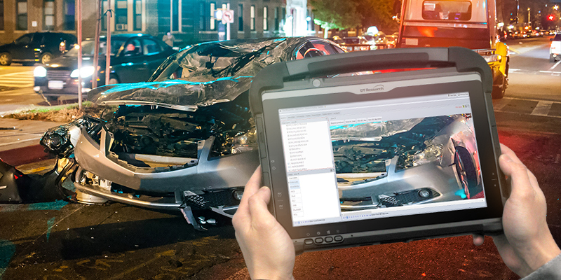
Traditionally, crime scene processing has involved manual measurements to construct diagrammatic representations of crime scenes. This requires a lot of work and time, and it may not produce an accurate depiction of a scene.
It takes time to factually map a crime scene. It sometimes takes the longest and is the most laborious element of an investigation. But making a precise layout helps to keep track of the placement of the evidence and helps to put it into perspective, as well as be used later on to determine what happened. Diagrams can accurately depict scale and distance in a manner that photographs frequently cannot.
Over time, specifically made rugged tablets have been developed with capabilities for particular jobs that can reduce costs and time while producing better results. Additionally, forensic mapping and scene investigation has recently undergone a revolution thanks to the development of GNSS (Global Navigation Satellite System) RTK (Real-Time Kinematic) rugged tablets.
Scientifically reliable readings are now feasible with the GNSS tablets. These tough tablets can give centimeter-level measurement accuracy at a fraction of the expense and time of traditional land surveying tools. This increases the safety of first responders at accident scenes, natural disasters, and crime scenes.
The DT301Y-TR and DT382GL-TR Rugged GNSS Tablets are compact, military-grade tablets with 10”/8” touch screens designed specifically for use with GIS mapping applications. Real-Time Kinematic (RTK) satellite navigation, increases the accuracy of position data obtained via satellite-based positioning systems. This provides centimeter-level accuracy, these special tablets make it possible to create 3D Point Clouds, which satisfies the strict criteria needed to provide scientific evidence in court.
The DT301Y-TR and DT382GL-TR are military-grade with an IP65 rating, yet lightweight – allowing the versatility to be utilized in the field, office, and cars. These tablets have a dual-frequency GNSS module that utilizes nearby real-time reference points. Positioning 3D point clouds made from aerial photogrammetry with GPS, GLONASS, BeiDou, and GALILEO receivers requires an accuracy of 1 to 2 centimeters. Users can connect to an external antenna for more reliable receiving and survey-grade precision, or they can measure with the RTK GNSS location directly using a foldable antenna.
Below are the features and capabilities of the DT301Y-TR and DT382GL-TR Tablets that have been purpose-built for precision mapping in a variety of environments:
- Dual Frequency GNSS Module – GNSS L1 & L2 RTK that receives GPS, GLONASS, BeiDou and GALILEO signals up to 372 channels with RMS 10 mm + 1ppm accuracy.
- High-Performance CPU and Windows OS – Intel® 8th Generation Core i5 or i7/Pentium® Silver quad-core processor with Microsoft Windows® 10 IoT Enterprise. Tablets come with either 8 GB or 16 GB of RAM.
- Brilliant Sunlight-readable Display – A 10.1-inch/8-inch LED-backlight, sunlight-readable high-brightness screen with capacitive touch and 1920 x 1200/1280×800 resolution.
- Superior Wireless Connectivity – Long-Range Class 1 BT powers connectivity up to 1000 feet and 4G mobile broadband for LTE, HESPA+, GMS/GPRS/EDGE, EV-DO, Rev A, and 1xRTT.
- Superior Storage – For ideal field data collecting, the tablets can store up to 1 Terabyte of data.
- Military Standards – For use in harsh environments, the tablets are fully ruggedized to meet the highest durability standards with an IP65 rating, MIL-STD-810G for vibration and shock resistance, and MIL-STD-461F for EMI and EMC tolerance.
- High Capacity Hot-Swappable Battery Pack – Delivers 60 or 90 watts for up to 15 hours of continuous mobile communications.
- Accessories – The GNSS Tablets are complemented by a variety of accessories, including external antennas, pole mount cradles, detachable keyboards, battery charging kits, and digital pens.
By utilizing these rugged tablets with GNSS, law enforcement personnel can obtain the necessary measurements to recreate crime scenes in legal settings with precise accuracy to meet the requirements of the rules of evidence. They can more swiftly collect and interpret three-dimensional data to improve public safety in circumstances when it could otherwise be compromised.